Stand up for the facts!
Our only agenda is to publish the truth so you can be an informed participant in democracy.
We need your help.
I would like to contribute


Google Earth didn’t block the Suez Canal. The difference in color is from lighting, camera angles
If Your Time is short
-
The difference in water color for a portion of the canal is due to a day-to-day difference of lighting conditions and camera angles, which can cause color inconsistencies when satellite imagery is stitched together.
-
The same effect can be seen in other locations on Google Earth.
A giant container ship that found itself stuck sideways in the Suez Canal has finally been freed after creating a maritime traffic jam and disrupting global shipping.
But the incident spurred some online to claim that it was no accident and that Google Earth suspiciously blocked people from seeing the canal.
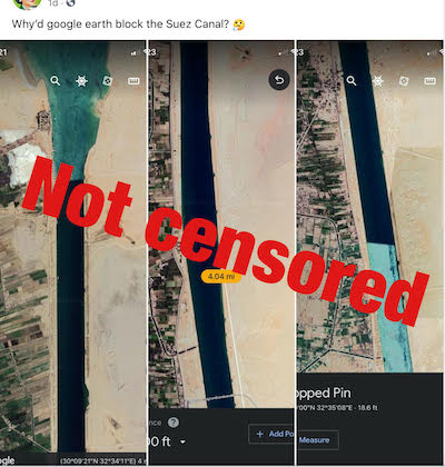
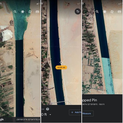
"Why’d Google earth block the Suez Canal?" one Facebook post questions while displaying screenshots from Google Earth that appear to show a large portion of the canal in a starkly darker blue compared to the rest of the passage.
"Very VERY interesting and worrisome," one commenter wrote.
"You know, because..censorship," another said.
The post was flagged as part of Facebook’s efforts to combat false news and misinformation on its News Feed. (Read more about our partnership with Facebook.)
Featured Fact-check
There is nothing nefarious about Google Earth’s imagery of the canal, which was there before the ship blockage occurred. The program does not operate in real time, and includes satellite, aerial, 3D and street view images that are collected over time from various providers and platforms.
"The mosaic of satellite and aerial photographs you can see in Google Maps and Google Earth is sourced from many different providers, including state agencies, geological survey organizations and commercial imagery providers," Matt Manolides, a satellite imagery expert at Google, said in a company blog post. "These images are taken on different dates and under different lighting and weather conditions."
The inconsistency in the water color of the Suez Canal is due to a difference of day-to-day lighting conditions and camera angles, and a similar effect can be seen at other locations on Google Earth.
For example, the first image shared in the post has a moderate amount of surface reflection, making it look blue, and waves can be seen in it. The third image has a high amount of surface reflection and is brighter than the first image due to more sun reflecting back up to the satellite.
The artifacts are sometimes produced when Google Earth stitches satellite images together. They normally aren't so noticeable, but satellite imagery of water can sometimes make stitching more visible, according to Google.
Other places that show a similar effect include the Panama Canal, Straits of Gibraltar and Loch Ness.
We rate this post False.
Our Sources
Facebook post, March 28, 2021
New York Times, After days of struggle, salvage crews freed the giant container ship, Updated March 29, 2021
Google Earth Help, How images are collected, Accessed March 29, 2021
Google Earth, Suez Canal, Accessed March 29, 2021
Google Earth, Panama Canal, Straits of Gibraltar, Loch Ness, Accessed March 29, 2021
Google, Ask a Techspert: How do satellite images work?, Oct. 5, 2020
Email interview, Google spokesperson, March 29, 2021
Browse the Truth-O-Meter
More by Samantha Putterman


Google Earth didn’t block the Suez Canal. The difference in color is from lighting, camera angles


Support independent fact-checking.
Become a member!
In a world of wild talk and fake news, help us stand up for the facts.